mail_outline sales@mediastorehouse.com
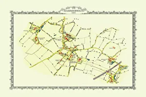
Old Map of the Village of Hammerwich in Staffordshire 1884PL047
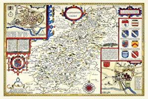
Old County Map of Northamptonshire 1611 by John SpeedA facimile of John Speeds historical map of Northamptonshire originally published for the " Theatre of the Empire of Great Britain"
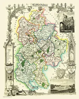
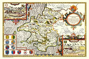
Old County Map of Bedfordshire 1836 by Thomas MouleThis is a fine decorative reproduction County Map of Bedfordshire from the First Edition series of Thomas Moule Maps, originally Published in 1836
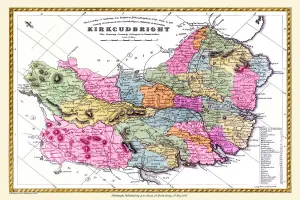
Old County Map of Kurkcudbright Scotland 1847 by A&C BlackA finely detailed facimile remastered in full colour from an antique original map of Kurkcudbright featured in A&C Blacks Atlas of 1847
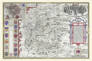
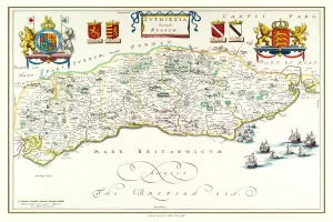
OldCounty Map of Wiltshire 1611 by John SpeedA facimile of John Speeds historical map of Wiltshire published for the " Theatre of the Empire of Great Britain", an atlas to accompany " a history of Great Britain"
Old Map of Liverpool 1785 by Surveyed by Charles EyesThis most impressive reproduction map has been completely art worked in full colour from the very rare antique original, large, black and white, detailed plan of Liverpool published by Charles Eyes
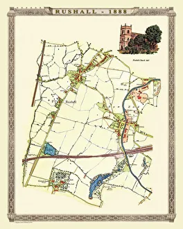
Old Map of Rushall to Daw End near Walsall 1888PL011
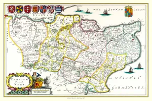
Old County Map of Kent 1611 by John SpeedA facimile of John Speeds historical map of Kent originally published for the " Theatre of the Empire of Great Britain", an atlas to accompany " a history of Great Britain"
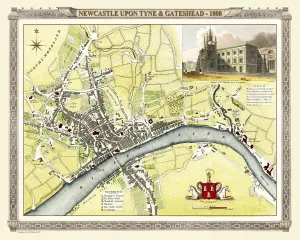
Old Map of Newcastle upon Tyne and Gateshead 1808 by Cole and RoperAn attractive and detailed early 19th century reproduction town plan of Newcastle upon Tyne and Gateshead 1808. First published by Cole and Roper as a finely engraved series of county maps
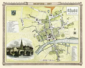
Old Map of Bedford 1807 by Cole and RoperAn attractive and detailed early 19th century reproduction town plan of Bedford, Bedfordshire. First published by Cole and Roper as a finely engraved series of county maps
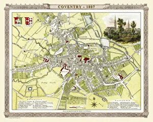
Old Map of Coventry 1807 by Cole and RoperAn attractive and detailed early 19th century reproduction town plan of Coventry 1805. First published by Cole and Roper as a finely engraved series of county maps
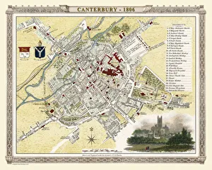
Old Map of Canterbury 1806 by Cole and RoperAn attractive and detailed early 19th century reproduction town plan of Canterbury 1806. First published by Cole and Roper as a finely engraved series of county maps
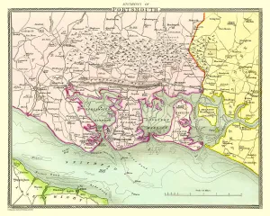
Old Map of the Environs of Portsmouth 1836 by Thomas MouleThis is a fine decorative reproduction Map of The Environs of Portsmouth from the First Edition series of Thomas Moule Maps, originally Published in 1836
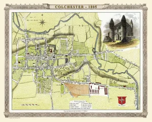
Old Map of Colchester 1805 by Cole and RoperAn attractive and detailed early 19th century reproduction town plan of Colchester 1805. First published by Cole and Roper as a finely engraved series of county maps
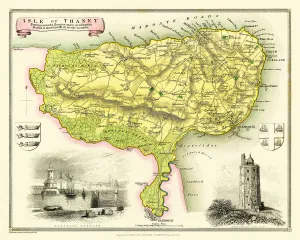
Old Map of The Isle of Thanet 1836 by Thomas MouleThis is a fine decorative reproduction Map of The Isle of Thanet from the First Edition series of Thomas Moule Maps, originally Published in 1836
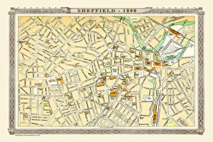
Old Map of Sheffield 1898 from the Royal Atlas by BartholomewA fine very detailed plan of the City of Sheffield remastered from an original contained within " The Royal Atlas of England and Wales" ; edited by J.G
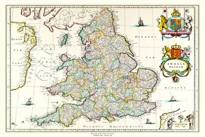
Old Map of England 1635 by Willem & Johan Blaeu from the Theatrum Orbis TerrarumThis detailed and most attractive reproduction map of England has been carefully art worked from a scan of an antique original
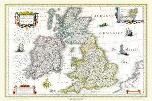
Old Map of The British Isles 1635 by Willem & Johan Blaeu from the Theatrum Orbis TerrarumThis detailed and most attractive reproduction map of The British Isles has been carefully art worked from a scan of an antique original
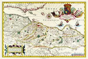
Old Map of Lothian - Scottish Lowlands by Johan Blaeu from the Atlas NovusThis detailed and most attractive reproduction map of the Scottish Lowlands, known as Lothian, has been carefully art worked from a scan of an antique original
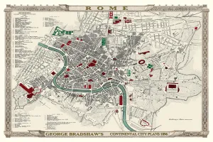
George Bradshaws Plan of Rome, Italy 1896This is a very detailed Plan of Rome showing the streets, canals, principal buildings, railways and railway stations, as well as the many ancient Roman sites
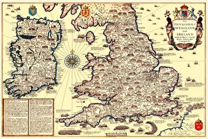
Old Map of The Invasions of England and Ireland by John SpeedA facimile of John Speeds historical map of the Invasions of England and Ireland originally published for the " Theatre of the Empire of Great Britain"
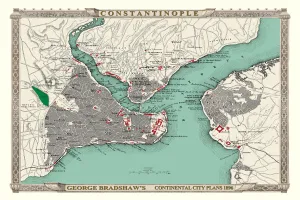
George Bradshaws Plan of Constantinople, Turkey 1896This is a detailed Plan of Constantinople showing the streets, canals, principal buildings, railways and railway stations
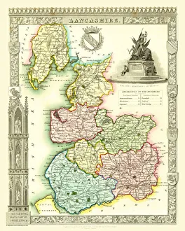
Old County Map of Lancashire 1836 by Thomas MouleThis is a fine decorative reproduction County Map of Lancashire from the First Edition series of Thomas Moule Maps, originally Published in 1836
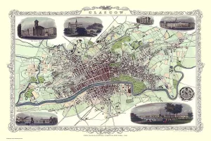
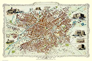
Old Map of Glasgow Scotland 1851 by John TallisThe River Clyde skirts its way through the heart of this famous Scottish City in this wonderful plan by Tallis originally published in 1851. There are six illustrations on the plan
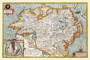
Old Map of The Province of Ulster 1611 by John SpeedA facimile of John Speeds historical map of the Province of Ulster originally published for the " Theatre of the Empire of Great Britain"
Old County Map of Kent 1648 by Johan Blaeu from the Atlas NovusThis detailed and most attractive reproduction map of Kent has been carefully art worked from a scan of an antique original
Old County Map of Pembrokeshire, Wales 1611 by John SpeedA facimile of John Speeds historical map of Pembrokeshire originally published for the " Theatre of the Empire of Great Britain"
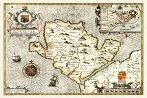
Old Map of The Isle of Anglesey, Wales 1611 by John SpeedA facimile of John Speeds historical map of Anglesey originally published for the " Theatre of the Empire of Great Britain", an atlas to accompany " a history of Great Britain"
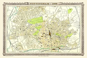
Old Map of Nottingham 1898 from the Royal Atlas by BartholomewA fine very detailed plan of the City of Nottingham remastered from an original contained within " The Royal Atlas of England and Wales" ; edited by J.G
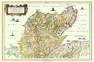
Old Map of Northern Scotland 1654 by Johan Blaeu from the Atlas NovusThis detailed and most attractive reproduction map of Northern Scotland has been carefully art worked from a scan of an antique original
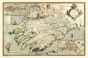
Old Map of The Province of Munster, Ireland 1611 by John SpeedA facimile of John Speeds historical map of the Province of Munster originally published for the " Theatre of the Empire of Great Britain"
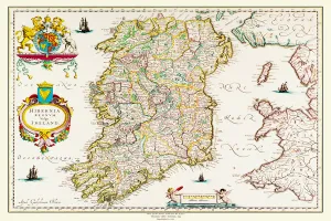
Old Map of Ireland 1635 by Willem & Johan Blaeu from the Theatrum Orbis TerrarumThis detailed and most attractive reproduction map of Ireland has been carefully art worked from a scan of an antique original
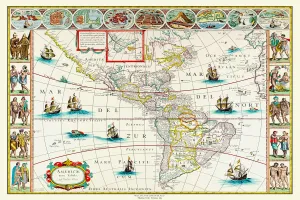
Old Map of The Americas 1635 by Willem & Johan Blaue from the Theatrum Orbis TerrarumThis detailed and most attractive reproduction map of The Americas has been carefully art worked from a scan of an antique original
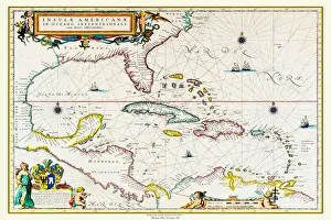
Old Map of The West Indies 1662 by Willem & Johan Blaue from the Theatrum Orbis TerrarumThis detailed and most attractive reproduction map of The West Indies has been carefully art worked from a scan of an antique original
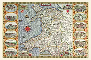
Old Map of Wales 1611 by John SpeedA facimile of John Speeds historical map of Wales originally published for the " Theatre of the Empire of Great Britain", an atlas to accompany " a history of Great Britain"
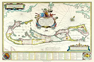
Old Map of The Island of Bermuda 1635 by Willem & Johan Blaue from the Theatrum Orbis TerrarumThis detailed and most attractive reproduction map of The Island of Bermuda has been carefully art worked from a scan of an antique original
Old County Map of Sussex 1648 by Johan Blaeu from the Atlas NovusThis detailed and most attractive reproduction map of Sussex has been carefully art worked from a scan of an antique original
Old Map of Manchester 1851 by John TallisThis John Tallis Victorian map, 1851, of Manchester in Lancashire covers the districts of Salford, Manchester, Ardwick, Chorlton and Hulme
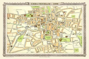
Old Map of Central Cheltenham 1898 from the Royal Atlas by BartholomewA fine very detailed town plan of Cheltenham from 1898 remastered from an original contained within " The Royal Atlas of England and Wales" ; edited by J.G
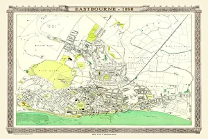
Old Map of Eastbourne 1898 from the Royal Atlas by BartholomewA fine very detailed plan of the Seaside Town of Eastbourne from 1898 remastered from an original contained within " The Royal Atlas of England and Wales" ; edited by J.G
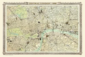
Old Map of Central London 1898 from the Royal Atlas by BartholomewA fine very detailed plan of Central London from 1898 remastered from an original contained within " The Royal Atlas of England and Wales" ; edited by J.G
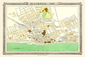
Old Map of Blackpool 1898 from the Royal Atlas by BartholomewA fine very detailed plan of the Town of Blackpool remastered from an original contained within " The Royal Atlas of England and Wales" ; edited by J.G
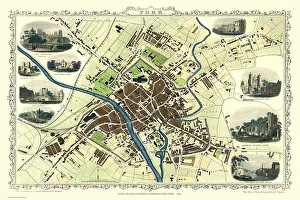
Old Map of York 1851 by John TallisThe River Ouse flows through the famous City of York, already its buildings are spreading outside its ancient walls. The 1851 John Tallis plan is illustrated with views of The Minster, Walmgate Bar
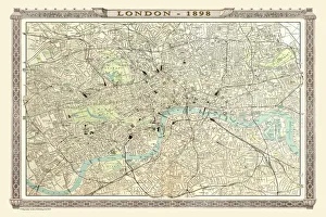
Old Map of London 1898 from the Royal Atlas by BartholomewA fine very detailed plan of the City of London remastered from an original contained within " The Royal Atlas of England and Wales" ; edited by J.G
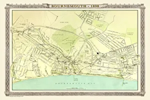
Old Map of Bournemouth 1898 from the Royal Atlas by BartholomewA fine very detailed plan of the Seaside Town of Bournemouth from 1898 remastered from an original contained within " The Royal Atlas of England and Wales" ; edited by J.G
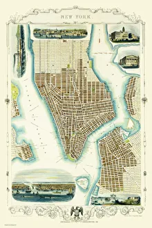
Old Map of New York United States of America 1851 by John TallisThis is a most attractive yet detailed plan 1851 by John Tallis of New York and districts of Jersey, Panovia, Hoboken, Brooklyn and Williamsburgh in the U.S.A
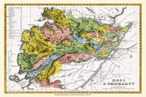
Old County Map of Ross and Cromarty Scotland 1847 by A&C BlackA finely detailed facimile remastered in full colour from an antique original map of Ross and Cromarty featured in A&C Blacks Atlas of 1847
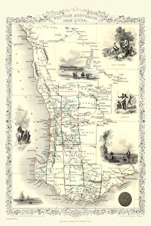
Western Australia and the Swan River 1851A fine facimile artworked from an antique original map of Western Australia and the Swan River, issued as part of the 1851 edition of John Tallis and Companys " The Illustrated Atlas