mail_outline sales@mediastorehouse.com
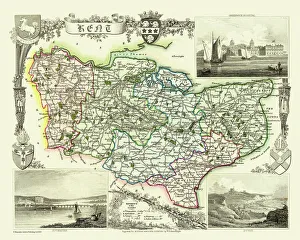
Old County Map of Kent 1836 by Thomas MouleThis is a fine decorative reproduction County Map of Kent from the First Edition series of Thomas Moule Maps, originally Published in 1836
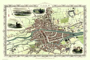
Old Map of Cork Ireland 1851 by John TallisIn this Victorian map of Cork in southern Ireland by John Tallis the North and South channels of the River Lee flow through the centre of the plan with the extensive Barracks dominating
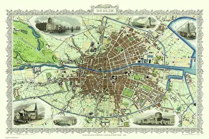
Old Map of Dublin Ireland 1851 by John TallisThis most attractive 19th Century map of Dublin in Southern Ireland by John Tallis 1851 shows all of Dublins districts, the Grand Canal networks and the arrival of the railways
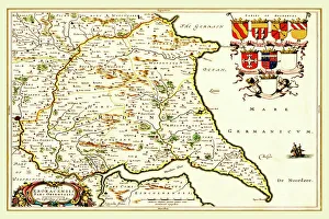
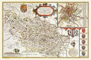
Old County Map of the East Riding of Yorkshire 1648 by Johan Blaeu from the Atlas NovusThis detailed and most attractive reproduction map of the East Riding of Yorkshire has been carefully art worked from a scan of an antique original
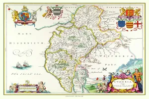
Old County Map of Cumbria 1648 by Johan Blaeu from the Atlas NovusThis detailed and most attractive reproduction map of Cumbria has been carefully art worked from a scan of an antique original
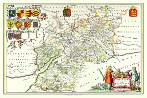
Old County Map of Gloucestershire 1648 by Johan Blaeu from the Atlas NovusThis detailed and most attractive reproduction map of Gloucestershire has been carefully art worked from a scan of an antique original
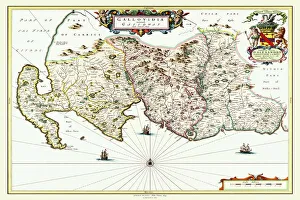
Old Map of Galloway Scotland 1654 by Johan Blaeu from the Atlas NovusThis detailed and most attractive reproduction map of Galloway has been carefully art worked from a scan of an antique original
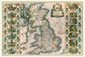
Old Map of Anglo Saxon Britain by John SpeedA facimile of John Speeds historical map of the Saxon Heptarchy originally published for the " Theatre of the Empire of Great Britain"
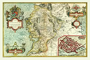
Old Map of The Province of Connacht, Ireland 1611 by John SpeedA facimile of John Speeds historical map of the Province of Connacht originally published for the " Theatre of the Empire of Great Britain"
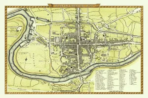
Old Map of Newcastle upon Tyne 1851 by John TallisNewcastle 1851, Gateshead is to the bottom of the John Tallis 1851 plan of Newcastle in Tyne and Wear with the famous High Level Railway crossing the River Tyne into Newcastle Central station
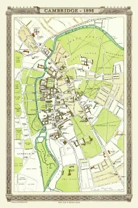
Old Map of Cambridge 1898 from the Royal Atlas by BartholomewA fine very detailed plan of the City of Cambridge from 1898 remastered from an original contained within " The Royal Atlas of England and Wales" ; edited by J.G
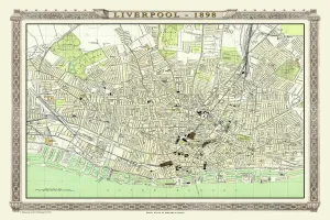
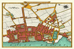
Old Map of Liverpool 1898 from the Royal Atlas by BartholomewA fine very detailed plan of the City of Liverpool remastered from an original contained within " The Royal Atlas of England and Wales" ; edited by J.G
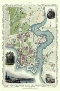
Old Map of Southampton 1851 by John TallisThe River Itchen dominates the 1851 John Tallis plan of Southampton in Hampshire with The Parks covering a great expanse to the top left
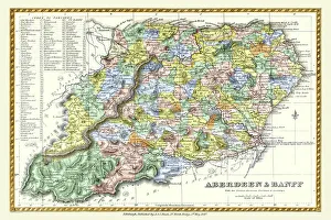
Old County Map of Aberdeen and Banff Scotland 1847 by A&C BlackA finely detailed facimile remastered in full colour from an antique original map of Aberdeen and Banff featured in A&C Blacks Atlas of 1847
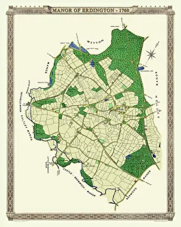
Old Map of The Manor of Erdington in Warwickshire 1760PL064
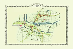
Old Map of the Village of Polesworth near Tamworth 1887PL60
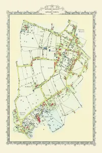
Old Map of Appleby Magna to Appleby Parva in Warwickshire 1885PL051
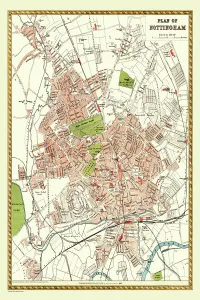
Old Map of Nottingham 1893 from the Comprehensive Gazetteer Atlas of England and WalesThis detailed reproduction plan of Nottingham has been re-worked from an antique originally published in the oComprehensive Gazetteer of England and Waleso 1893
Old Map of Birmingham 1795 by C. PyeJ073
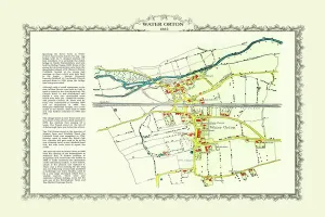
Old Map of the Village of Water Orton in Warwickshire 1882PL028-010-24X16
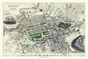
Old Map of Edinburgh 1834 by the S. D. U. KF006
Old Map of Chester 1795 by John StockdaleAn interesting, very detailed, reproduction 18th century street plan of the City of Chester Engraved for and published John Stockdale
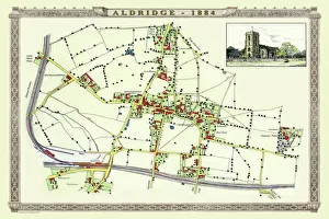
Old Map of the Village of Aldridge in Staffordshire1884PL001
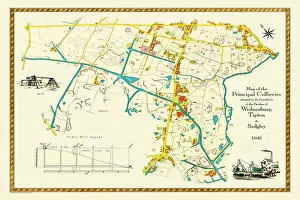
Old Map of the Collieries of Tipton, Sedgley and Wednesbury 1848PL005
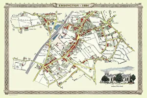
Old Map of the Village of Erdington in the West Midlands 1884PL007
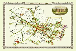
Old Map of Cannock Town in Staffordshire 1886PL004
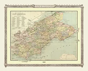
Old Map of the Counties of Fife and Kinross from the Philips Handy Atlas of 1882PHA014
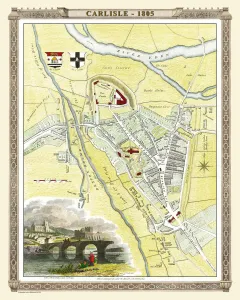
Old Map of Carlisle 1805 by Cole and RoperAn attractive and detailed early 19th century reproduction town plan of Carlisle 1805. First published by Cole and Roper as a finely engraved series of county maps
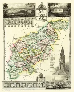
Old County Map of Northamptonshire 1836 by Thomas MouleThis is a fine decorative reproduction County Map of Northamptonshire from the First Edition series of Thomas Moule Maps, originally Published in 1836
Old County Map of Yorkshire West Riding 1611 by John SpeedA facimile of John Speeds historical map of Yorkshire West Riding originally published for the " Theatre of the Empire of Great Britain"
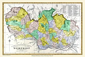
Old County Map of Dumfries Scotland 1847 by A&C BlackA finely detailed facimile remastered in full colour from an antique original map of Dumfries featured in A&C Blacks Atlas of 1847
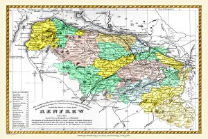
Old County Map of Renfrew Scotland 1847 by A&C BlackA finely detailed facimile remastered in full colour from an antique original map of Renfrewshire featured in A&C Blacks Atlas of 1847
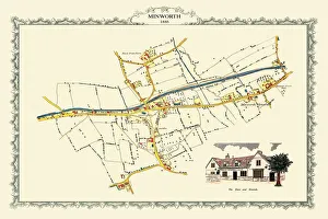
Old Map of the Village of Minworth in Warwickshire 1886PL034
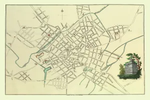
Old Map of Liverpool 1725J119
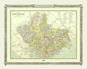
Old Map of the County of Kirkcudbright from the Philips Handy Atlas of 1882PHA019
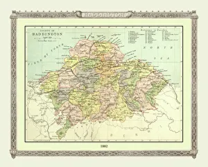
Old Map of the County of Haddington from the Philips Handy Atlas of 1882PHA016
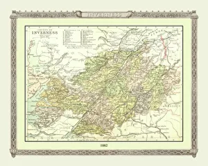
Old Map of the County of Inverness from the Philips Handy Atlas of 1882PHA017
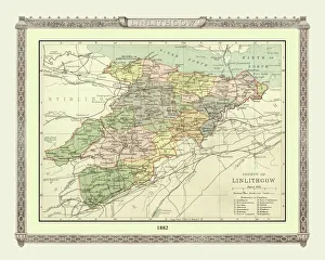
Old Map of the County of Linlithgow from the Philips Handy Atlas of 1882PHA021
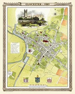
Old Map of Gloucester 1805 by Cole and RoperAn attractive and detailed early 19th century reproduction town plan of Gloucester 1805. First published by Cole and Roper as a finely engraved series of county maps
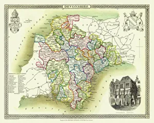
Old County Map of Devonshire 1836 by Thomas MouleThis is a fine decorative reproduction County Map of Devonshire from the First Edition series of Thomas Moule Maps, originally Published in 1836
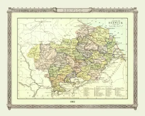
Old Map of the County of Berwick from the Philips Handy Atlas of 1882PHA006
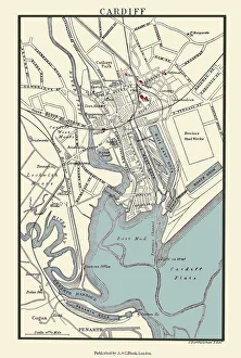
Old Map of Cardiff 1890 by A&C BlackJ133
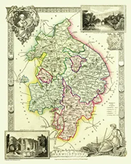
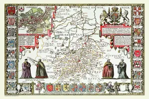
Old County Map of Warwickshire 1836 by Thomas MouleThis is a fine decorative reproduction County Map of Warwickshire from the First Edition series of Thomas Moule Maps, originally Published in 1836
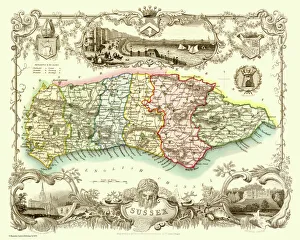
Old County Map of Sussex 1836 by Thomas MouleThis is a fine decorative reproduction County Map of Sussex from the First Edition series of Thomas Moule Maps, originally Published in 1836
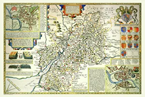
Old County Map of Gloucestershire 1611 by John SpeedA facimile of John Speeds historical map of Gloucestershire originally published for the " Theatre of the Empire of Great Britain"
Old County Map of Cambridgeshire 1611 by John SpeedA facimile of John Speeds historical map of Cambridgeshire originally published for the " Theatre of the Empire of Great Britain"
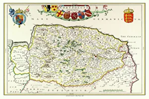
Old County Map of Norfolk 1648 by Johan Blaeu from the Atlas NovusThis detailed and most attractive reproduction map of Norfolk has been carefully art worked from a scan of an antique original
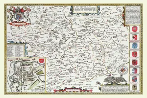
Old County Map of Leicestershire 1611 by John SpeedA facimile of John Speeds historical map of Leicestershire originally published for the " Theatre of the Empire of Great Britain"