mail_outline sales@mediastorehouse.com
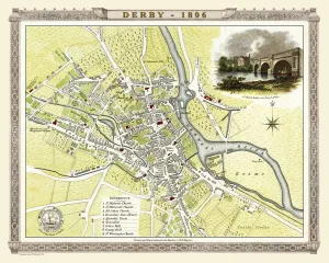
Old Map of Derby 1806 by Cole and RoperAn attractive and detailed early 19th century reproduction town plan of Derby 1805. First published by Cole and Roper as a finely engraved series of county maps
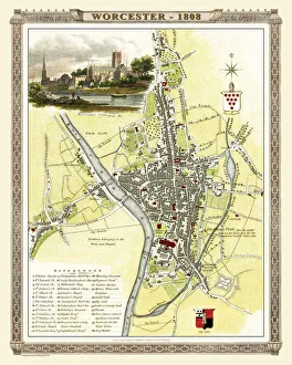
Old Map of Worcester 1808 by Cole and RoperAn attractive and detailed early 19th century reproduction town plan of Worcester 1808. First published by Cole and Roper as a finely engraved series of county maps
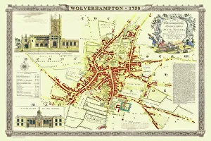
Old Map of Wolverhampton 1750 by Isaac TaylorJ066
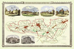
Old Map of Stoke on Trent and the Potteries 1831G148
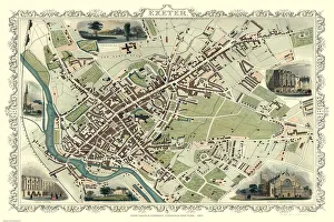
Old Map of Exeter 1851 by John TallisThe River Exe skirts the South West of this plan of Exeter in Devon by John Tallis 1851 with the Exe Bridge providing direct access through the heart of Exeter
Old Map of the City of Cambridge 1836 by Thomas MouleThis is a fine decorative reproduction Map of The City of Cambridge from the First Edition series of Thomas Moule Maps, originally Published in 1836
Old Map of Cheltenham 1825 by Griffith sFine reproduction in full colour of Griffiths new historical description of Cheltenham and its vicinity originally published in 1825
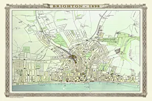
Old Map of Brighton 1898 from the Royal Atlas by BartholomewA fine very detailed plan of the Seaside Town of Brighton from 1898 remastered from an original contained within " The Royal Atlas of England and Wales" ; edited by J.G
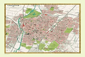
Old Map of Leicester 1903J105
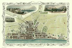
Old Map of Brighton 1851 by John TallisA most attractive Victorian plan of Brighton in Sussex by John Tallis 1851 showing its famous Chain Pier reaching out into the English Channel
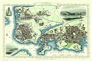
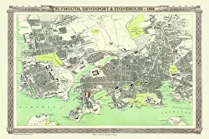
Old Map of Plymouth Devonport and Stonehouse 1851 by John TallisAn attractive Victorian plan of Plymouth in Devon by John Tallis 1851, with Morice Town, Higher Stoke, Stoke, Devonport and Stonehouse
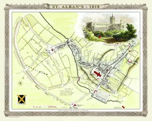
Old Map of St Albans 1810 by Cole and RoperAn attractive and detailed early 19th century reproduction town plan of St Albans 1810. First published by Cole and Roper as a finely engraved series of county maps
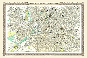
Old Map of Manchester and Salford 1898 from the Royal Atlas by BartholomewA fine very detailed plan of the City of Manchester and Salford remastered from an original contained within " The Royal Atlas of England and Wales" ; edited by J.G
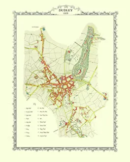
Old Map of Dudley 1835J037
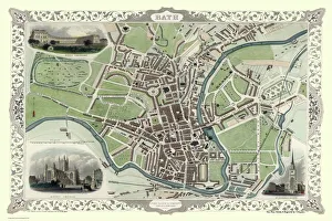
Old Map of Bath 1851 by John TallisThis is a splendid Victorian map by John Tallis 1851 of the historic Spa City of Bath in North East Somerset nestled between a bend on the River Avon
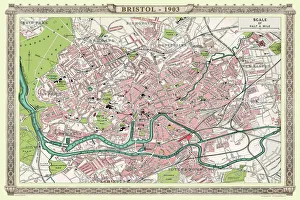
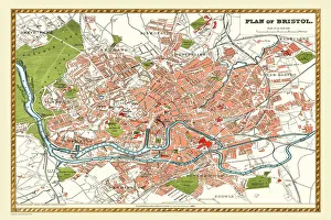
Old Map of Bristol 1903J104
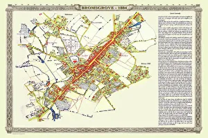
Old Map of the Town of Bromsgrove in Worcestershire 1884PL003
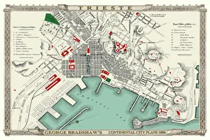
George Bradshaws Plan of Trieste, Italy 1896This is a very detailed Plan of the Port and City of Trieste showing the Port, streets, canals, principal buildings, railways and railway stations
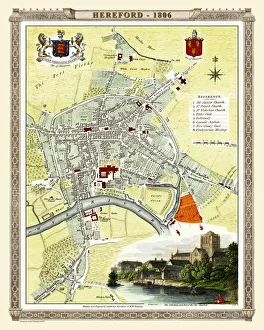
Old Map of Hereford 1806 by Cole and RoperAn attractive and detailed early 19th century reproduction town plan of Hereford 1806. First published by Cole and Roper as a finely engraved series of county maps
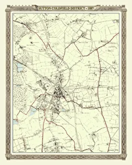
Old Map of the District of Sutton Coldfield in the West Midlands 1887PL016
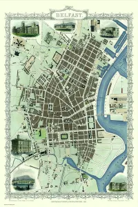
Old Map of Belfast 1851 by John TallisThe River Lagan dominates the west side of this John Tallis 1851 plan of Belfast with Queens Bridge crossing into the town of Belfast in Northern Ireland. There are six splendid illustrations
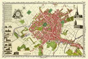
Old Map of Birmingham 1851 by John TallisThis attractive plan of mid Victorian Birmingham in the Midlands by John Tallis 1851 shows the first railways and important canal network. The work is attractively presented with eight illustrations
Old Map of Plymouth, Devonport and Stonehouse 1898 from the Royal Atlas by BartholomewA fine very detailed plan of the Port City of Plymouth with Devonport and Stonehouse, remastered from an original contained within " The Royal Atlas of England and Wales" ; edited by J.G
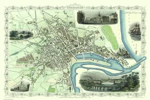
Old Map of Aberdeen 1851 by John TallisAberdeen in Scotland nestled on the River Dee with its famous Victorian Park and Harbour, John TallisAEs 1851 town plan perfectly captures this historic Scottish town during mid Victorian times
Old Map of Bradford 1851 by John TallisIn this John Tallis 1851 map of Bradford in west Yorkshire the railways are now well established, buildings now stretch out from the centre of Bradford along the main artery roads
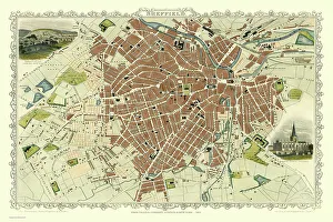
Old Map of Sheffield 1851 by John TallisA fine 1851 map by John Tallis of Victorian, industrial Sheffield in South Yorkshire that shows the steady growth of industry and housing to the left of the plan
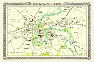
Old Map of Durham 1898 from the Royal Atlas by BartholomewA fine very detailed plan of the City of Durham remastered from an original contained within " The Royal Atlas of England and Wales" ; edited by J.G
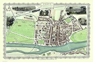
Old Map of Perth Scotland 1851 by John TallisThis 1851 John Tallis Victorian map of Perth in Scotland shows town sandwiched between the South Inch and North Inch. The plan shows only one bridge across the River Tay into Perth
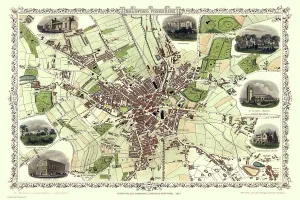
Old Map of Leeds 1851 by John TallisThis map of Leeds in West Yorkshire by John Tallis 1851 features the districts of Woodhouse Carr, Great Woodhouse, Little London, New Town, Little Woodhouse, New Wortley, Holbeck, and Hunslet
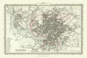
Old Map of Bristol 1866 by Fullarton & CoThis is an interesting and detailed reproduction Victorian town plan of Bristol which was originally published in John Marius Wilsons The Imperial Gazeteer of England and Wales (A.Fullarton & co)
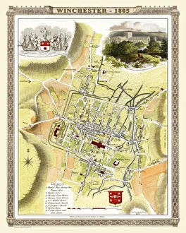
Old Map of Winchester 1805 by Cole and RoperAn attractive and detailed early 19th century reproduction town plan of Winchester 1805. First published by Cole and Roper as a finely engraved series of county maps
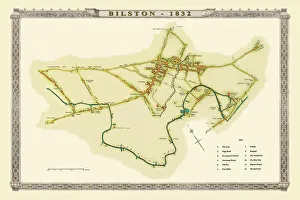
Old Map of Bilston 1832J036
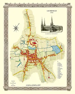
Old Map of Lichfield with inset view of Lichfield Cathedral surveyed in 1781J035
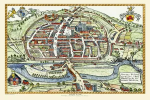
Old Map of Exeter by Braun and Hogenburg 1618A fine reproduction of Frans Hogenbergs city plan of Exeter originally published as one of the many in the city atlas which was intended to be a companion to the earlier Theatrum Orbis Terrarum
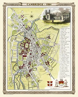
Old Map of Cambridge 1804 by Cole and RoperAn attractive and detailed early 19th century reproduction town plan of Cambridge 1804. First published by Cole and Roper as a finely engraved series of county maps
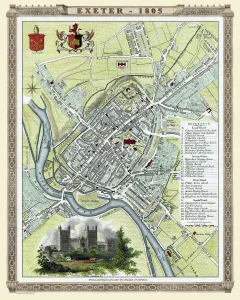
Old Map of Exeter 1805 by Cole and RoperAn attractive and detailed early 19th century reproduction town plan of Exeter 1805. First published by Cole and Roper as a finely engraved series of county maps
Old Map of Bristol 1893 from the Comprehensive Gazetteer Atlas of England and WalesThis detailed reproduction plan of Bristol has been re-worked from an antique originally published in the oComprehensive Gazetteer of England and Waleso 1893
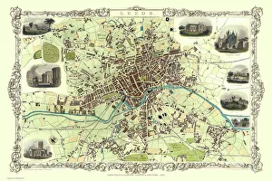
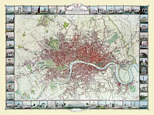
Old Map of London 1851 by John TallisCommemorating the Great Exhibition of Industry of All Nations 1851, this magnificent plan of London, re-created and art worked directly from the antique original
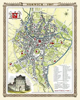
Old Map of Norwich 1807 by Cole and RoperAn attractive and detailed early 19th century reproduction plan of the City of Norwich 1807. First published by Cole and Roper as a finely engraved series of county maps
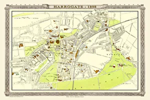
Old Map of Harrogate 1898 from the Royal Atlas by BartholomewA fine very detailed town plan of Harrogate from 1898 remastered from an original contained within " The Royal Atlas of England and Wales" ; edited by J.G
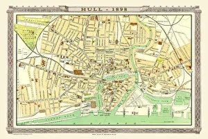
Old Map of Hull 1898 from the Royal Atlas by BartholomewA fine very detailed plan of the City of Hull remastered from an original contained within " The Royal Atlas of England and Wales" ; edited by J.G
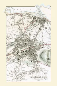
Old Map of Edinburgh and Leith 1864 by G. W. SwansonSplendid reproduction map of Edinburgh originally drawn and engraved by G.H.Swanson. The plan of Edinburgh and Leith shows exceptional detail
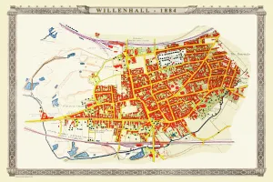
Old Map of the Town of Willenhall in the West Midlands 1884PL024
Old Map of Birmingham Surveyed in 1750 by Thomas HansonJ071
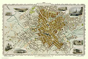
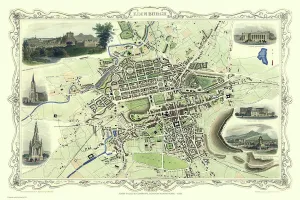
Old Map of Edinburgh Scotland 1851 by John TallisThis Victorian map of Edinburgh in Scotland by John Tallis is dominated with a view to the top right across Edinburgh from the north- west towards Edinburgh Castle
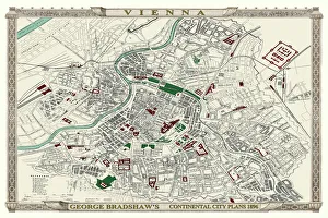
George Bradshaws Plan of Vienna, Austria 1896This is a very detailed Plan of Vienna, which features streets, canals, principal buildings, railways and railway stations
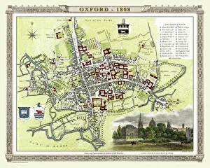
Old Map of Oxford 1808 by Cole and RoperAn attractive and detailed early 19th century reproduction plan of the City of Oxford 1808. First published by Cole and Roper as a finely engraved series of county maps
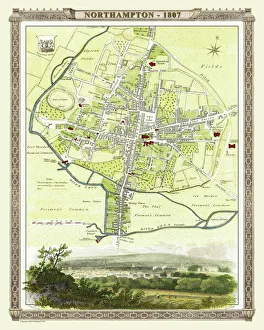
Old Map of Northampton 1807 by Cole and RoperAn attractive and detailed early 19th century reproduction town plan of Northampton 1807. First published by Cole and Roper as a finely engraved series of county maps