mail_outline sales@mediastorehouse.com
Old Map of West Canada 1851 by John TallisA fine facimile artworked from an antique original map of West Canada, issued as part of the 1851 edition of John Tallis and Companys " The Illustrated Atlas and Modern History of the World"
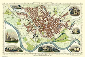
Old Map of Preston 1851 by John TallisThe River Ribble in Lancashire by John Tallis 1851 with a most rural presentation of Preston surrounded by numerous meadows and open fields. The plan is beautifully finished with seven illustrations
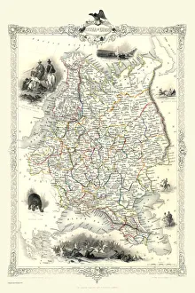
Russia in Europe 1851A fine facimile artworked from an antique original map of Russia in Europe, issued as part of the 1851 edition of John Tallis and Companys " The Illustrated Atlas
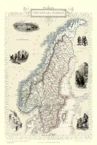
Sweden & Norway 1851A fine facimile artworked from an antique original map of Sweden and Norway, issued as part of the 1851 edition of John Tallis and Companys " The Illustrated Atlas
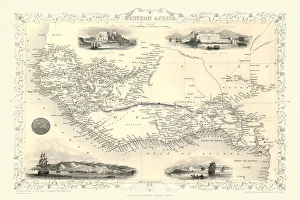
Western Africa 1851A fine facimile artworked from an antique original map of Western Africa, issued as part of the 1851 edition of John Tallis and Companys " The Illustrated Atlas
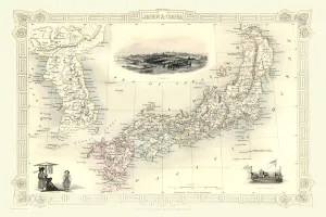
Japan & Korea 1851A fine facimile artworked from an antique original map of Japan and Korea, issued as part of the 1851 edition of John Tallis and Companys " The Illustrated Atlas
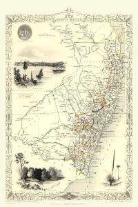
New South Wales 1851A fine facimile artworked from an antique original map of New South Wales, Australia, issued as part of the 1851 edition of John Tallis and Companys " The Illustrated Atlas
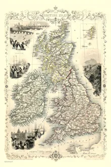
British Isles 1851A fine facimile artworked from an antique original map of The British Isles, issued as part of the 1851 edition of John Tallis and Companys " The Illustrated Atlas
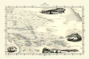
Polynesia, or Islands in the Pacific Ocean 1851A fine facimile artworked from an antique original map of Polynesia, or Islands in the Pacific Ocean, issued as part of the 1851 edition of John Tallis and Companys " The Illustrated Atlas
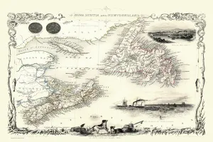
Old Map of Nova Scotia and Newfoundland 1851 by John TallisA fine facimile artworked from an antique original map of Nova Scotia and Newfoundland, issued as part of the 1851 edition of John Tallis and Companys " The Illustrated Atlas
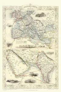
Overland Route to India 1851A fine facimile artworked from an antique original map of the Overland Route to India, issued as part of the 1851 edition of John Tallis and Companys " The Illustrated Atlas
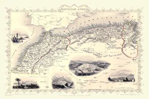
Old Map of Northern Africa 1851 by John TallisA fine facimile artworked from an antique original map of Northern Africa, issued as part of the 1851 edition of John Tallis and Companys " The Illustrated Atlas
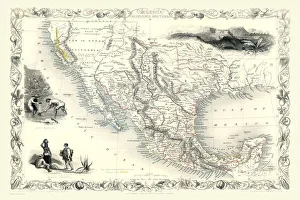
Old Map of Mexico, California & Texas 1851by John TallisA fine facimile artworked from an antique original map of Mexico, California and Texas, issued as part of the 1851 edition of John Tallis and Companys " The Illustrated Atlas
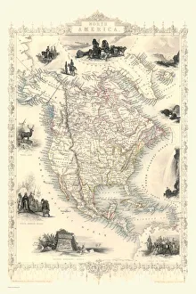
Old Map of North America 1851 by John TallisA fine reproduction artworked from an antique original map of North America, issued as part of the 1851 edition of John Tallis and Companys " The Illustrated Atlas
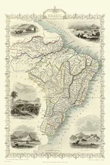
Old Map of Brazil 1851 by John TallisA fine facimile artworked from an antique original map of Brazil, issued as part of the 1851 edition of John Tallis and Companys " The Illustrated Atlas and Modern History of the World"
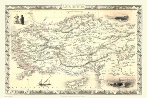
Asia Minor 1851A fine facimile artworked from an antique original map of Asia Minor, issued as part of the 1851 edition of John Tallis and Companys " The Illustrated Atlas and Modern History of the World"
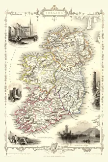
Ireland 1851A fine facimile artworked from an antique original map of Ireland, issued as part of the 1851 edition of John Tallis and Companys " The Illustrated Atlas and Modern History of the World"
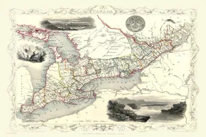
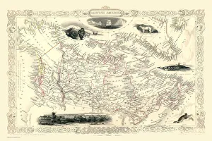
Old Map of British America, or Canada 1851 by John TallisA fine facimile artworked from an antique original map of British America or Canada, issued as part of the 1851 edition of John Tallis and Companys " The Illustrated Atlas
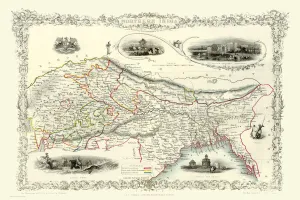
Northern India 1851A fine facimile artworked from an antique original map of Northern India, issued as part of the 1851 edition of John Tallis and Companys " The Illustrated Atlas
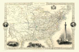
Old Map of the United States of America 1851 by John TallisA fine facimile artworked from an antique original map of the United States of America, issued as part of the 1851 edition of John Tallis and Companys " The Illustrated Atlas
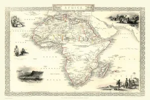
Old Map of Africa 1851 by John TallisA fine facimile artworked from an antique original map of the Continent of Africa, issued as part of the 1851 edition of John Tallis and Companys " The Illustrated Atlas
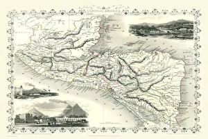
Old Map of Central America 1851 by John TallisA fine facimile artworked from an antique original map of Central America, issued as part of the 1851 edition of John Tallis and Companys " The Illustrated Atlas
Gibraltar, Malta, and Ionian Isles 1851A fine facimile artworked from an antique original map of Gibraltar, Malta and Ionian Isles, issued as part of the 1851 edition of John Tallis and Companys " The Illustrated Atlas
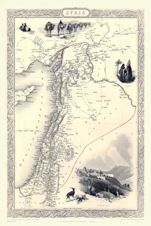
Syria 1851A fine facimile artworked from an antique original map of Syria, issued as part of the 1851 edition of John Tallis and Companys " The Illustrated Atlas and Modern History of the World"
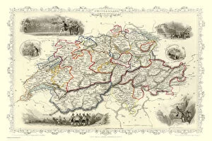
Switzerland 1851A fine facimile artworked from an antique original map of Switzerland, issued as part of the 1851 edition of John Tallis and Companys " The Illustrated Atlas and Modern History of the World"
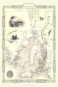
Part of South Australia 1851A fine facimile artworked from an antique original map of Part of South Australia, issued as part of the 1851 edition of John Tallis and Companys " The Illustrated Atlas
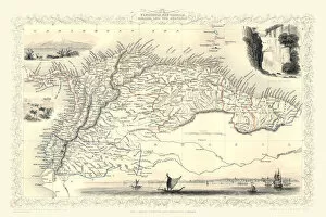
Old Map of Venezuela, New Granada, Equador and The Guayanas 1851 by John TallisA fine facimile artworked from an antique original map of Venezuela, New Granada, Equador and The Guayanas, issued as part of the 1851 edition of John Tallis
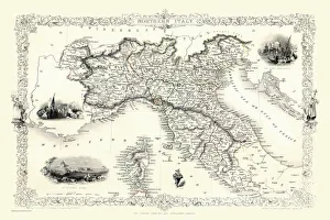
Northern Italy 1851A fine facimile artworked from an antique original map of Northern Italy, issued as part of the 1851 edition of John Tallis and Companys " The Illustrated Atlas
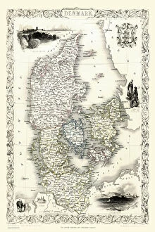
Denmark 1851A fine facimile artworked from an antique original map of Denmark, issued as part of the 1851 edition of John Tallis and Companys " The Illustrated Atlas and Modern History of the World"
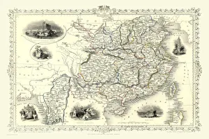
China & Burma 1851A fine facimile artworked from an antique original map of China and Burma, issued as part of the 1851 edition of John Tallis and Companys " The Illustrated Atlas
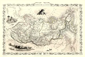
Russia in Asia 1851A fine facimile artworked from an antique original map of Russia in Europe, issued as part of the 1851 edition of John Tallis and Companys " The Illustrated Atlas
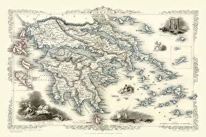
Greece 1851A fine facimile artworked from an antique original map of Greece, issued as part of the 1851 edition of John Tallis and Companys " The Illustrated Atlas and Modern History of the World"
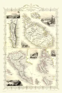
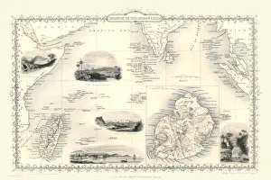
Islands in the Indian Ocean 1851A fine facimile artworked from an antique original map of the Islands in the Indian Ocean, issued as part of the 1851 edition of John Tallis and Companys " The Illustrated Atlas
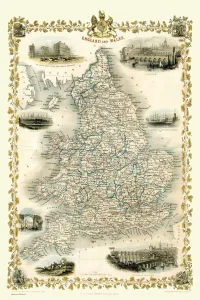
England & Wales 1851A fine facimile artworked from an antique original map of England and Wales, issued as part of the 1851 edition of John Tallis and Companys " The Illustrated Atlas
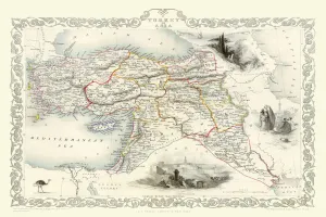
Turkey in Asia 1851A fine facimile artworked from an antique original map of Turkey in Asia, issued as part of the 1851 edition of John Tallis and Companys " The Illustrated Atlas
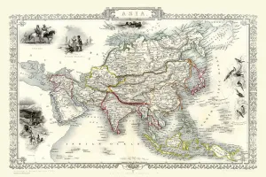
Asia 1851A fine facimile artworked from an antique original map of the Continent of Asia, issued as part of the 1851 edition of John Tallis and Companys " The Illustrated Atlas
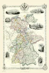
Germany 1851A fine facimile artworked from an antique original map of Germany, issued as part of the 1851 edition of John Tallis and Companys " The Illustrated Atlas and Modern History of the World"
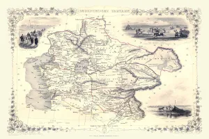
Independent Tartary 1851A fine facimile artworked from an antique original map of the Independant Tartary, issued as part of the 1851 edition of John Tallis and Companys " The Illustrated Atlas